ASTER DEM/Ortho Software
SILCAST ver.3.00 Released
|

Demo mode operation is
possible without license
|
|
|
 Function Overview Function Overview
SilcAst software is developed exclusively for ASTER. The main functions are digital elevation extraction, ortho rectification, and Level-1B data generation. Either of Level-1A and Level-1B is available as an input source data for DEM and Ortho functions.
DEM Generation
- No need to enter ground control point
- No need to use GTOPO30
- Geoid height corrected
- Body of water automatically identified
- High speed processing optimized for ASTER
- Elevation data every 1 arcsecond for high quality and 4 arcseconds for medium quality
Ortho Rectification
- UTM map projection
- No need to externally import elevation data
- Elevation plane available in addition to ortho rectified image data
Level-1B Generation
- UTM map projection (path-oriented)
Major Meta Data Extraction
Note:
The geolocation errors in the geometric DB of ver.3.0 or older will be automatically corrected by the silcast ver.1.03 or later software.
Supported operatiing systems
Windows 7 or later
Macintosh OSX 10.12 or later
Linux (Special Order)
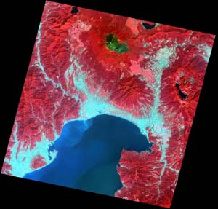
Processed Example
 |
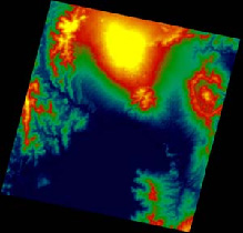 |
| Mt.Fuji, Ortho-rectified Image | Mt.Fuji, Elevation |
|